
After ripping through the Florida peninsula, Hurricane Milton weakened to a category one hurricane and its center moved out of the state into the Atlantic Ocean.
But forecasters warned that stormy winds and rain were continuing in eastern parts of the state.
The storm comes just two weeks after Hurricane Helene caused extensive damage across the southeastern United States.
When did Hurricane Milton hit Florida?
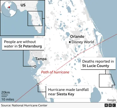
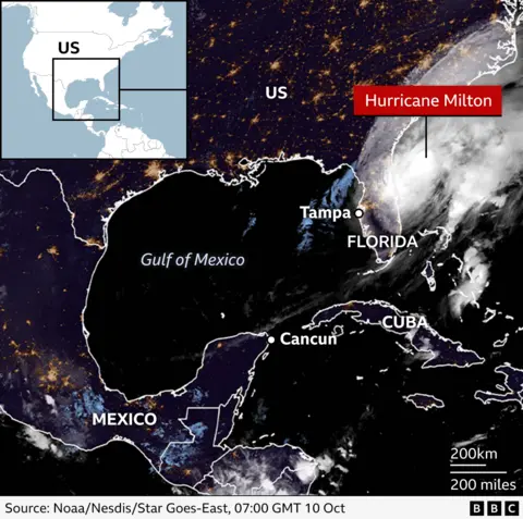
Milton made landfall as a category three hurricane in Siesta Key, Florida – a coastal community about 50 miles (80 km) south of Tampa – at around 8:30 p.m. EST on Wednesday (3:30 p.m. BST on Thursday), according to the National Hurricane Center. (NHC).
Nearly 3.4 million homes and businesses were without power as of Thursday morning, dozens of homes were destroyed and at least four deaths were reported.

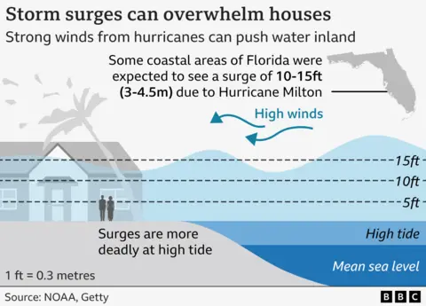
Forecasters continue to warn of torrential rain, flash flooding, high winds and possible storm surges – which occur when water moves inland from the coast – several feet high along the northeast coast Florida.
Gov. Ron DeSantis said in a news conference Wednesday night that at least 116 tornado warnings were issued across Florida on Wednesday, with 19 tornadoes confirmed so far in the state.
Where is Hurricane Milton?
With the most recently recorded wind gusts of up to 85 mph (140 km/h), Milton is now entering the Atlantic Ocean and is forecast to pass north of the Bahamas late Thursday.
Its sheer size means its effects are felt much more widely than the shaded cone shown above.
In addition to most of Florida, the storm’s effects were also felt in Georgia and South Carolina.
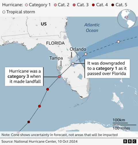
During its multi-day journey, Milton moved east from the Gulf of Mexico, where it was classified as a category one hurricane on Sunday. It also swept across Mexico’s Yucatan Peninsula.
Before it hit Florida, forecasters said it “wobbled” south, forcing forecasters to change its path slightly.
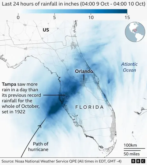
The storm affected some areas recently devastated by Hurricane Helene. Tampa, which has a population of more than three million people in the broader metropolitan area, is just north of Siesta Key, where the storm made landfall.
Where is the evacuation area after Hurricane Milton?
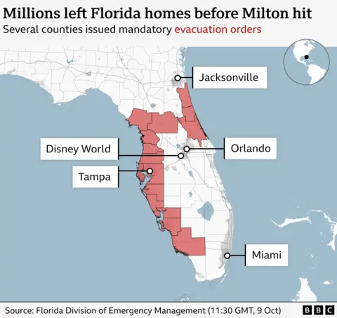
Traffic jams formed and airports were declared closed as Floridians were told to prepare for the state’s largest evacuation effort in years. Officials said Milton could be the worst storm to hit the area in about a century.
As the storm approached, most counties were in an official state of emergency and evacuations were ordered up and down Florida’s west coast.
Issued by the disaster management agency a list and map about evacuation orders spanning dozens of counties. Several large shelters were also prepared as a last resort for those trapped.
What are storms and how do they form?
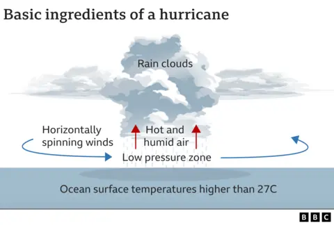
A hurricane – sometimes called a cyclone or hurricane – is a type of tropical storm that forms in the North Atlantic Ocean. They bring strong winds and heavy rain.
When ocean air is warm and moist, it rises and then begins to cool – causing clouds to form.
Sometimes this rising air can move away at the top of the storm faster than it can be replaced at the surface, causing surface pressure to drop.
The drop in pressure causes the winds to speed up with more air then being pulled in as the storm strengthens.
The National Oceanic Atmospheric Association (Noaa) predicts the 2024 hurricane season will be more active than usual. Rising average sea temperatures due to human-caused climate change are partly to blame.
How are storms classified?
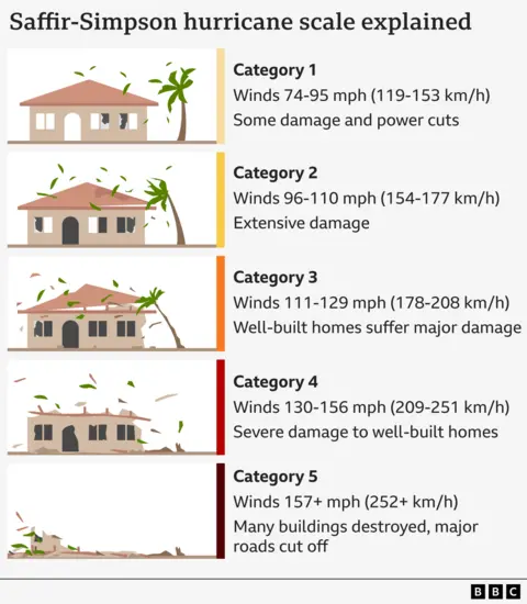
Hurricanes are divided into five categories based on their wind speed.
Milton was repeatedly classified as a Category 5 storm – the highest level – but weakened as it approached the US coast, becoming a Category 3 storm.
After landfall, it was further downgraded to category one.
How relevant is climate change?
Hurricane Milton rapidly strengthened as it passed through exceptionally warm waters in the Gulf of Mexico, where sea surface temperatures are about 1-2 degrees Celsius higher than average.
Warmer waters mean storms can gain more energy, potentially leading to higher wind speeds.
A warmer atmosphere can also hold more moisture – up to around 7% for every 1C increase in temperature. This means rainfall from storms can be more intense.
And global sea levels have been rising in recent decades, largely due to global warming.
This makes it more likely that a given storm surge will lead to coastal flooding.
In Florida, average sea levels have risen more than 7 inches (18cm) since 1970, according to US government data.
A full scientific analysis is needed to quantify the exact role climate change played in Storm Milton.
But its rapid intensification is consistent with expectations about how these storms are changing in a warming world.